International monitoring of glacier location and condition commenced in 1894 during the Commission Internationale des Glaciers in Switzerland. Now multiple organizations continue to monitor glaciers, as discussed below. Contemporary monitoring activities combine field and remote sensed data to analyze glaciers in global terms. Integration of new technologies with multi-level processes is a key objective in glacier monitoring.
Glaciers in Canada are monitored by Natural Resources Canada, under the program "The State and Evolution of Canada’s Glaciers", led by the Geological Survey of Canada and including collaborations with the Canadian Space Agency and several universities across the country.
Glacier research groups at several institutions, including University of British Columbia, Simon Fraser University, University of Northern British Columbia, University of Alberta, University of Calgary, University of Lethbridge, University of Toronto, Trent University, University of Ottawa, Carleton University, and Memorial University of Newfoundland, add to the federal government effort through an array of research studies on glacier dynamics, mass balance processes, glacier and ice sheet modelling, and glacier-climate interactions.
Graham Cogley at Trent University has helped to extend the World Glacier Inventory (data such as glacier area and length from about 131,000 glaciers) as well as a global glacier mass balance inventory from just over 350 glaciers (out of more than 200,000 glaciers worldwide!).
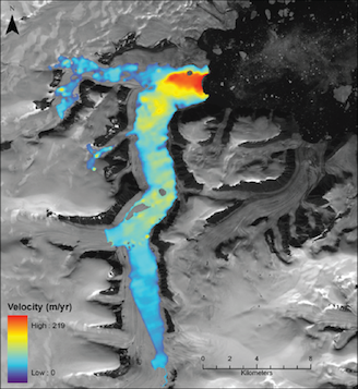
RADARSAT-2 image and analysis
(D. Burgess, NRCan).
Currently, the three main international bodies that gather and collate glacier inventory and mass balance data are the U.S. National Snow and Ice Data Center (NSIDC), Glacier Land Ice Measurements from Space (GLIMS), and the World Glacier Monitoring Service (WGMS), based at the University of Zurich. NSIDC serves primarily as the data portal for glacier data compiled through GLIMS and WGMS via a legion of individuals from over 30 countries who collect, analyze, and provide these data each year. The data are published through the annual Global Glacier Change Bulletin as well as a series called Fluctuations of Glaciers, published every five years. The most recent glacier change bulletin includes values for 151 glaciers worldwide (WGMS, 2015).
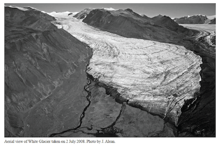
Long term records from several Canadian glaciers are included in the WGMS database and reports, including three sites in western Canada (Place and Helm Glaciers, British Columbia, and Peyto Glacier, Alberta) and four sites in the Canadian Arctic (White and Baby Glaciers, Axel Heiberg Island; Devon Ice Cap; Meighen Ice Cap; Figures 2 and 3). Most of these sites have records that began in the 1960s, with other discontinued and occasional observational records from numerous other sites in both western and northern Canada.
Table 1: Longterm Canadian glacier mass balance sites
| Glacier | Record Dates | Location | Latitude | Longitude |
|---|---|---|---|---|
| Baby Glacier | 1960-2005 | High Arctic, Canada | 79.43°N | 90.97°W |
| Devon Ice Cap NW | 1961-2014 | High Arctic, Canada | 75.42°N | 83.25°W |
| Helm | 1975-2013 | Coast Mountains, Canada | 49.97°N | 123.00°W |
| Meighen Ice Cap | 1976-2014 | High Arctic, Canada | 79.95°N | 99.13°W |
| Melville South Ice Cap | 2010-2014 | High Arctic, Canada | 75.40°N | -115.00°W |
| Peyto | 1966-2013 | Rocky Mountains, Canada | 51.67°N | 116.53°W |
| Place | 1965-2013 | Rocky Mountains, Canada | 50.43°N | 122.60°W |
| Sentinel | 1966-1989 | Coast Mountains, Canada | 49.90°N | 122.98°W |
| White | 1960-2013 | High Arctic, Canada | 79.45°N | 90.67°W |
Table 2: Mass Balance Data
| Glacier Name | MB 2012 | AEL 2012 | MB 2013 | AEL 2013 | AEL if MB=0 |
|---|---|---|---|---|---|
| Devon Ice Cap NW | -767 | 1465 | -658 | 1605 | 1007 |
| Helm | --- | 1930 | -2950 | --- | 1999 |
| Meighen Ice Cap | -1484 | --- | -1280 | >267 | --- |
| Melville South Ice Cap | -1544 | --- | -1709 | >715 | --- |
| Peyto | -360 | 2680 | -910 | 2730 | 2610 |
| Place | -120 | 2053 | -2300 | --- | 2081 |
| White | -951 | 1442 | 45 | 858 | 912 |
Overall, the period 2001-2010 had the greatest ice loss of the last five decades in the Canadian Arctic. Of the 151 glaciers chronicled by WGMS there was a mean mass balance of -740 mm water equivalent per year. Observed mass losses in recent years and the last decade are consistent with worldwide trends. The 2013-2014 year alone has surpassed this record mean with a -750 mm water equivalent per year loss. Additionally, since 2010 the percent of observed glaciers with positive mass balance has gone from 33% to >20% (WGMS, 2015). These extreme records are on track to continue and worsen through the decade with no improvement expected.
A monitoring program aiming to gather accurate and timely measurements of a statistically significant amount of glaciers world-wide is being conducted by the PTAA-GMB (Precipitation - Temperature - Area - Altitude - Glacier Mass Balance) Project. The measurements will track daily mass balance changes in each of 200 glaciers in order to understand current, past and future conditions. Wendell Tangborn, of Hymet, Inc., has developed a computer-model approach to produce highly accurate snowmelt forecasts and glacier mass balance reports. The data are derived from low-altitude weather observations and streamflow forecasts, with no aid from manual measurements. This allows for the observation methods to be easily replicated and the ability to monitor a relevant amount of these remote features.
References
Glacier Links
Material on this page was provided by Professor Shawn Marshall (Canada Research Chair in Climate Change, Department of Geography, University of Calgary, Alberta) and edited by Maren Pauly and Tristan Mills(Department of Geography, University of Waterloo).