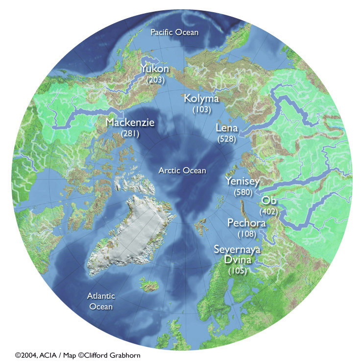
proportional to arrow thickness (discharge in km2) (Clifford
Grabhorn, 2004). Click figure for larger image.
Many river systems across the circumpolar Arctic drain northwards into the polar seas and eventually the Arctic Ocean. Figure 1 displays the main Arctic discharge rivers: Mackenzie, Yukon, Kolyma, Lena, Yenisey, Ob, Pachora and Severnaya Dvina. The relative discharge of each river is depicted numerically and visually as the thickness of the river in the diagram. Subsurface groundwater flow is another form of discharge in the Arctic ocean, however, it occurs at much smaller magnitudes than river discharge. During the winter, with onset river ice formation, the total discharge decreases. Quantity of discharge peaks in the spring and early summer with river ice break-up. In Canada, the total watershed area that drains into the Arctic Ocean is 3.5 million km2. The total drainage into the Arctic Ocean each year from circumpolar regions is 5250km3. Of this total drainage, 13% is from Europe, 41% North America and Greenland and 46% from Asia. Across these various drainage areas, the characteristics of drainage and seasonality are highly differential (ACIA, 2005; Environment Canada, 2012).
There is large variety in the data collected on river systems across the Arctic due to the many countries that occupy land in northern regions. Some countries thoroughly and regularly investigate their rivers while others do so sporadically. Both the quality and availability of the data vary wildly and no standard long-term observations of circumpolar Arctic rivers is in place between countries. This difficulty in obtaining consistent data over a period of time makes it harder to analyze for trends. One proposed solution is to establish a coordinated effort to observe the properties of Arctic rivers with international standards. This would create a wealth of data useful for analyzing physical, ecological, and climatic trends (McClelland, et al., 2015).
Material on this page was edited and provided by Maren Pauly and Tristan Mills, Department of Geography, University of Waterloo.